![]()
|
|
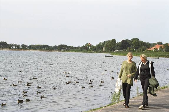
Kalundborg Fjord |
|
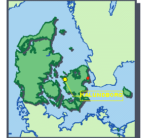
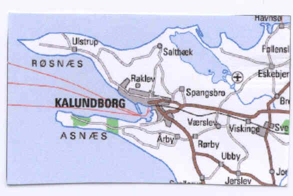
Table of contents
The
Kalundborg Fjord, Hans Guldager Christiansen
Introduction,
Line, 2.u
Our own investigations of Kalundborg
Fjord Cristian and Morten, 2.u
Plant and animal life in the Fjord
Fish
The plaice, ( Pleuronectes
platessa). Marie-Louise, 2.w
The Stone Reef of Røsnæs
Røsnæs
Stone-reef, Camilla, 2.u
EU-habitat-areas,
Camilla, 2.u
The Fauna on and around Røsnæs
Reef, Sussie and Lenette, 2.a
Algae in a
stone-reef, Sussie and Linette, 2.a
Seals at
Røsnæs, Lykke, 2b
Environmental conditions
Oil pollution
Tina 2u, Thomas 2t
The decomposing of oil,
Gregers Thomas and Martin 2.w
Oil spill in
Kalundborg Fjord (inlet), Katrine and Elisabeth, 2w
Catlink,
Jakob 2w, Marianne 2u, Filip 2t.
The Danish
bathing water, Maja and Anne 2.t, Maika and Lotte 2.w
Bathing
water tests, Louise 2w
TBT, Jeanette 2.b
The Kalundborg Fjord
The National
Surroundings
The Kalundborg Fjord
Exercise Directions for a Practical Investigation of the
Fjord
Investigating the physical and
chemical qualities of the environment
A
Survey of the Animal Life
In the autumn of 1999 the class of the 2nd BI at Kalundborg Gymnasium worked with the subject, Kalundborg Fjord. First we examined the physical and chemical qualities and animal life of the fjord. This was carried out at a place in the inner part of the inlet. Then we worked theoretically with subjects which are crucial to the biology of the fjord.
One group has written about our practical examinations. Another group has written about the animals and plants that may be found in the fjord and especially about the stone-reef at the outer-most point of Røsnæs. Others have worked with environmental conditions, such as pollution of oil, the fast ferries (Cat-Link), the quality of the bathing water and TBT.
In the final pages of this document we have included a general account of the Danish waters and especially of Kalundborg Fjord and also an introduction to our practical work.
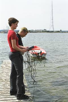
On August 23rd and 30th, the entire A level biology class went for a measure trip at
Kalundborg Fjord. We took some tests from the bottom of Houget (the inner fjord of
Kalundborg ) to examine the animal life there.
We took our tests with a special tube with a precise area of 0,01 m2 .
The tube was pressed down to the bottom of the fjord, in a way so that we got as much material as possible. Afterwards the tube was taken up very carefully so it was possible to examine the sand.
We took 12 tests from the bottom in this way.
The result of these tests showed a wide spectra of animals. No less than 8 species were observed: bristle worm (Nereis diversicolor), snail (Peringia ulvae), bristle worm (?), cockle (Cardium edule), shrimp (Crangon crangon), Baltic clam (Macoma baltica), soft clam (Mya arenaria) and lugworm (Arenicola marina).
No less than 567 individuals were found within an area of 1,0 m2
the individual that was best represented was Nereis .
With all these results, it was possible to find the actual biomass of the animals: 269 g/m2 in wet weight.
During our measuring trip we also performed some physical and chemical tests. First we tested the amount of nitrate and phosphate in the water. The result of these tests were pretty good, because we found no N- or P-salts.
Inspired by these results, we measured the visibility of the water, too, it was measured to 6,5 meters. From these results we concluded that the amount of nitrate and phosphate in the water was low not because of a large amount of algae, but because there were no salts in the water, at all. If the visibility had been low, it could have been an indication of a large number of algae in the water, caused by a large amount of N- and P-salts.
The next thing we did was to test the concentration of oxygen in the water. At the surface the percentage of oxygen was measured to 89 %. And at the bottom it was measured to 69 %.
We also measured the salinity of the water, and the low percentage was not surprising, at all, as Kalundborg Fjord gets most of its water from the Baltic Sea which has a very low salinity. The rest of the water comes from the North Sea which has a higher salinity.
The actual salinity in the water was measured to 15 per thousand
The plaice is a right-turned fish and looks much like a flounder both in colour and in form. The plaice is a quite slippery fish. Between the eyes it has a cowed made of bone. On the eye-side there are remarkable light and dark red spots. On a sexually mature fish there is a bright circle around the red spots. The base colour is like the bottom of the sea because the plaice is a fish that lives down there. The colour variates in all brown colours. The blind side is white some times with brown spots.
The plaice lives everywhere in Denmark and has very good conditions in Kalundborg inlet because it likes to live in salt and not too deep water. The plaice does not come too close to the coast, but lives out on deep water in the inlet. It prefers to live where there is a lot of sand so it can hide from all enemies. In the day the plaice is digging itself down. In bad weather and at night the plaice comes out to hunt. It feeds on worms, small crayfish, prawns, small mussels, crabs and small fishes.
The plaice begins to spawn in January and can continue to March and April. It has rather long migrations, wandering up to about 30 km. in a day. It is a very attractive fish to the fisherman as it is the most prestigous fish to eat.
A stone-reef is a sea bottom covered with stone. Stone-reefs can date from the Ice Age, when the stones were pushed forward by the glaciers. Sand and mud cover many of the stone-reefs, but in other places the stones lie freely, because the strong current carries the sand away. Some stone-reefs are above the surface of the water while others are below. The fish and plants on a reef vary from one to another, because of the amount of nutrients in the water.
Røsnæs stone-reef is lying in a twisted curve from the very end of Røsnæs. The stone-reef is below the surface of the water and is covered by sand, clay and gravel. The reef is found at a depth of 0-8 meters, and because of the good currents we can find a lot of nutrients and therefore also an exclusive life of fishes and plants.
EU-habitat-areas are places of preservation. These EU-habitat-areas are selected by The ministry of Environment and Energy and The ministry of forest and nature. The stone-reef and the areas that surround it at the very end of Røsnæs, have been chosen as one of these EU-habitats of preservation, in order to protect the stone-reef, and its animals and plants. The cliffs at Røsnæs are also protected because there are many rare species of birds, which normally live in Southern Europe. The plants and the thicket on the slopes make the cliffs a sanctuary for migrating birds in the spring. In this season a large number of species of birds have been observed on the cliffs.
There are many sorts of naval organisms at Røsnæs reef andonly a small part of them can be mentioned here. The reef is divided into four zones depending on the depth. There are the blue zone, the red zone, the green zone and the twilight zone. In each zone different sorts of animals live, but some of the animals live in all three zones - only not to the same extent. The many different algae and other plants which live on the reef supply good food for all the animals. The plants give all the animals energy and oxygen.
The blue zone in the Great Belt is a good place for ordinary mussels, because there is a powerful current in the water. That supplies new nutrients to the mussels, and the current removes the waste products.
In the red and green zone there are still a lot of animals, but now other sorts. There are fewer ordinary mussels and starfish. The blood red Delesseria is dominating here. There aren’t memorandums on the fauna in this zone.
The twilight zone is the deepest part of the reef and the habitat of many different coelenterates. Of those coelenterates can be mentioned crinoids, and turbularia. There are also a lot of starfish, sun star (Solaster) and hermit crabs.
The ordinary mussels are sitting on the leaves of the algae and it is not all algae which can handle that. The mussels have an adhesive tape with which they stick to everything.
The algae on the bottom have good conditions of life in a stone-reef. Algae stick to permanent surfaces, like stones, with sucking dishes. The big granite boulders are often thick with vigorous vegetation. The vegetation changes according to the size of the stone and the season.
The perennial algae are often bigger than annual ones. The perennial algae grow on the stones, while the annual ones grow in the crown leaves of the perennial ones. Those annual algae are called epiphytes. The algae are divided after their content dyestuff. The algae have different colours because of their granules. Fissured shaped algae lay as a painting cover on the stones in colours like red, light-red and brown. The vertical algae, which are carried by the water are soft and have a stalk and leaves.
Algae have no flower which is why they can’t carry seed. They reproduce themselves in different ways. Most of them by spore formation, but some reproduce themselves by division. They use all their surface to dig up nutrients so they can reproduce. The young algae are flowing around a while till they stick on a stone.
On the stone reef at Røsnæs you can observe the common seal. Especially in their breeding season and in their shedding season they can be seen on the reeves or by the sand banks, because here it is easier for them to flee from land, since the reeves and sand banks have very deep water all the way to the shore.
In the water the seals are very vivacious and curious, but on land they are very shy and they escape into the water if they hear only the tiniest noise. If you see a seal it is important that you don’t scare it, because this can seriously effect the seal’s well-being. However, there are some places in Denmark where the seals have got used to the constant interruptions. For instance, you can meet seals on some beaches, in harbours and very close to boats, because they are so curious.
We know that one result of frequent disturbances of the seals is that young seals cannot suck the optimal 800 g milk a day from their mother. Thus the young seal doesn’t get a layer of blubber which is thick enough to survive in the cold water; but also it will have trouble surviving in the coming starving-period ( where it has to learn how to capture food by itself). Then the seal’s weight will go down further, because it needs more energy to keep warm in the water. Moreover, the seal is so small and weak that it may easily catch infections, get wounded, and get lice, which means that the young seal will have very bad chances to survive during the winter.
Quite recently people have discussed a total protection of the seals. The fishermen say that we ought to remove total protection, because the seals are a nuisance to their work. The seals eat too many fish and destroy the fishermen’s nets. In addition to that, they say that Denmark is not big enough to have wild nature, i.e. where you let the seals breed without human interfering. Other people say that it would be unacceptable to start hunting the seals. You have to consider the fact that the seals have gradually come to trust us, because we haven’t hunted them for about 20 years. Therefore if we suddenly start hunting them, they will lose confidence in us and escape from the areas around Denmark.
Oil which is spilt in nature causes big damage in coast areas and on beaches, ecological systems, animals and plants. For example, when sea birds (eiders, black ducks and so on) come in touch with oil, their feathers stick together, which ruins their normal, effective, water-repellent and warmth-protecting plumage. The damage is often so big that the bird only has small chances of surviving, since its loss of heat is too big and its body-temperature will fall dramatically. Sea birds can also get internal injuries from eating oil-polluted food or by “cleaning” their plumage. Shallow areas, which in the summer are very productive and the home of fry, are also very vulnerable to oil-pollution. The reactivity of the fish is reduced and their muscle-control will gradually deteriorate. Ultimately serious changes can happen in their pattern of behaviour.
Compared to the 1970s, when about 100.000 sea birds died, the number of lost birds due to oil pollution has decreased considerably.
In fact, oil pollution is no longer considered as a real menace to the population, but it is still of topical interest as regards animal protection. For example 20.000 black ducks were killed due to the oil-pollution in January/March 1998.
When fighting oil pollution it is important that both the biological and climatical conditions are at their optimum. In nature there are some conditions that will help the decomposing along, but even in such cases the outcome may be ambivalent.
If a storm is blowing the oil can spread over a large area and can therefore become hard to control; coasts can be smeared with oil, which may be harmful to animal life. But, on the other hand, the wind can also mix oil with water and thereby increase the surface area so the decomposing of micro-organisms can begin immediately.
The temperature also has an important influence on the extent of the damages. Part of the oil evaporates (up to 50%) in the course of a week in our waters. But if the oil gets out for example in the arctic regions the temperature there is so low that the oil continues being solid in shape. And if the temperature is so low that there will be ice floes, the oil would settle below those, which will make decomposing extremely difficult.
The sunlight is also an important factor when decomposing oil. This is due to the fact that the sunlight together with oxygen react with some oil components in the so-called “photochemical oxidation”. By this oxidation the oil is transformed into more easily soluble compounds, as alcohols and acid. These are more easily demolished but are poisonous for bacteria that are also part of the decomposing process.
After some time the oil will turn into a thick splotch that by time will take the form of water emulsion – a tar-like substance with up to 80% water. The emulation often takes a lot of time and depends on the motion of the waves. Huge oil floes can drift around on the surface of the water for a long time without being demolished. The small remaining oil particles will mostly cluster to grains of sand or sink to the bottom where micro-organisms will decompose them.
Micro-organisms can only affect the oil if it is on the borderline between oil and water. In addition they must have a certain amount of nutrients to start the decomposing process. You can clearly see the ineffectiveness of micro-organisms in the months after the spring blossoming of the seaweeds. So it is very important that there is some water circulation caused by the motion of the waves, which can whirl the nutrient from the bottom to the surface. Even if there are optimum conditions it can take years before the micro-organisms have decomposed the last oil to carbon dioxide and water.
What can be done to reduce the consequences of oil pollution? It is very difficult to fight it once the damage has been done. The oil may be transformed into other forms, but it will still be there and in the end it is nature that has to straighten things up. If an accident occurs in an area which contains a lot of birds one might consider removing the oil from the surface of the water or dispersing it, in that way protecting the birds. By adding oil chemical dispersion mediums during the process of powerful stirring (wave motion) it is possible to cause the water to emulsify and thereby disperse the oil at every level. But there is a flip to that coin; it may cause a massive damage to the natural environment of the water where plants and animals will suffer severely.
In recent years the Danish government have decided on a lot of new guidelines which will ensure the Danish oil preparedness the best possible basis in the fight against water pollution. Thus Denmark will in every way live up to the standards of its neighbouring countries.
The Ministry of Environment is responsible for the administration, the SOK (Søværnets Operative Komando) makes sure that the surveillance of the ocean is carried out by aeroplanes and ships. They also take samples of polluted water and from ships that are suspected of having polluted Danish waters. Every commercial ship has a duty to report to the SOK any oil- or chemical escape they observe. The NERI (National Environmental Research Institute of Denmark) receives the samples from the SOK and carries out the chemical analysis. They have participated in the development of the NORDTEST-method, which they are now using. The NORDTEST-method is used to test suspected links between the pollution and ships under suspicion. Every type of oil has its own chemical structure. The method has been accepted as valid evidence against ships found guilty of polluting. If the method becomes standard procedure all over the world it will be possible for laboratory technicians to exchange information and make joint databases on oil and oil products. In that way it would be easier to capture and punish the offenders.
Kalundborg Harbour is an industrial harbour with a big power station and an oil refinery. Thus there is a lot of transport by sea for example by the oil tankers. An oil spill from one of these ships will have disastrous consequences to fauna and flora.
Formerly chronic pollution of the water was an embarrassment in Kalundborg Fjord. One of the big sinners in this field was the oil refinery which every year let out 16,4 tons of hydrocarbons through their discharge water. A total amount of 24,6 tons of hydrocarbons from various sources were released every year. Only 21,4 tons per year disappeared by evaporation, decomposition or further transport to the Great Belt. That is to say 3,2 tons was still in the inlet (information from 1982).
Today the conditions have been improved because the oil refinery has entered into an agreement with the power station ,Asnæsværket”. The agreement implies that the oil refinery sends part of their discharge water to the power station which will use it for their production of steam. In addition, they have their own wastewater treatment plant, which the water must pass through before it is discharged into the inlet.
The worst case of oil spill that has taken place in Kalundborg Fjord was on September 29, 1998, when the big oil supply vessel “Buna” was to deliver oil to the oil tanker “Nunki”. By accident the tanker tore a hole, which was 1,5 by 30 cm, in the hull of the “Buna”. Now the thick fuel oil started to pour out in the inlet. The two environmental ships the “Gunnar Seidenfaden” and the “Marie Miljø” were sent for. As soon as they arrived they began the clearing which took about 10 hours. The fast clearing was a result of the fact that fuel oil does not lie on the surface of the water as a membrane: it stays together in portions. In total 99000 litres oil gushed out in the inlet.
The catamaran ferries (a very fast ferry with two hulls) navigating in the Kalundborg inlet caused a lot of speculation, criticism and spirited discussions. For example there were problems with noise and the fact that thestern waves of these ferries were much bigger than normal waves, which gave many uncomfortable surprises to anglers and bathers.
The problems were almost solved after many complaints: speed restrictions were agreed on and the shipping route was rearranged. But the local fishermen were still anxious. The new route ran through their fishing areas and they feared collisions and destruction of teir trawls.
The Fishermen would like the catamaran ferry Cat Link to use the same route as the traditional ferries Ask and Urt had done for years, but the problem with the old route was, that it went straight through a preserved area (close to the island of Samsø).
The strongest criticism against Catlink was aimed at the ferry’s disturbance of bird and animal life in this preserved area around the Stavns inlet at Samsø. Studies were carried out by many observations from the ferries, showing that it was not the ferries themselves which were the distracting element, but the subsequent stern waves.
The investigations also showed that breeding birds got used to the ferries, while migratory birds did not adapt to the disturbances during the short time they stayed at Samsø before they moved on. The seals were not affected by the noise from the ferries, either.
In Denmark there are about 5000 km of coastline with beaches and water worth bathing in. Every year the water is controlled hygienically by the county authorities from May till October, so that it can be published every year where it is possible to bathe. It must be said that there are some places in Denmark where it isn’t advisable to bathe, even though the water is hygienically okay, for instance there can be problems because of the wind or current conditions. It’s the counties and the doctors that issue bans on bathing.
Water samples (approximately 1500 a year) are taken one metre below the sea surface, and the samples are not all taken in the same kind of weather. The samples are analysed for colon bacteria. In the EU, 2000 colon bacteria pr. 100 ml are allowed in the water, but it's the highest level. It’s assumed that the test reflects the influence of waste water on the bathing locations.
Non polluted bathing water contains no or less than ten colon bacteria pr. 100 ml water. Water with more than ten colon bacteria pr 100 ml is not accepted as bathing water. It can be water that is permanently polluted, but it can also be water which is only temporarily polluted. Bad bathing water in Denmark is mainly caused by waste water, but it can also be caused by the following things:
Bad draining systems near streams and watercourses, which may result in floods during heavy showers.
2) Lack of cleaning at the water treatment plant
3) Too short or damaged water discharge pipes.
4) Seepage of animal manure from the earth.
In every municipality tests are taken of the bathing water. This is done by a measurer, an employee from the local environmental- and food control. The bath water tests are taken in places which have been selected by the community physician and employees from the county council district. Day and time are stipulated when the tests are going to be taken. It’s important that the tests are taken at some distance from the shore, because there must be absolutely no material from the bottom in the test; therefore the tests are often taken from a bathing jetty or a boat.
When the measurer is at work, he/she measures the current and wind, and checks the visibility of the water, in addition he/she must check if the water is discoloured, filled with algae or if it smells. Last but not least, he/she collects a sample of the water. Among other things the sample is used to find the number of coliform bacteria. (number of coliform bacteria: number of coliform bacteria pr. 100 ml.). Under normal conditions 10 tests will be taken per season: 1st May – 1st October. If too many bacteria are found the number of tests will be increased for a certain period of time.
To get a reliable result of the tests we made it was important that the equipment we used was sterile, and the pipette was replaced after every dilution. When the water tests were picked up, we also used a pipette to put some undiluted water on a plate of agar. After that we diluted the test with sterile water so the test became 1/10. It was written on the plate of agar. We repeated this until the test was 1/100. It was written on the plate and agar which group and how many times the test was diluted. After this the tests were put in a heating cupboard at 44°C for 2-3 days and nights.
The result of the tests showed that except for one place, the number of coliform bacteria was fine. In Houget, where we studied animals, the number of coliform bacteria was 510 coliform bacteria per/100ml.
TBT is a shortening of the poisonous Tributyltin, which is an organic tin compound. TBT is used in bottom paint for ships. If ships are not bottom painted they will soon develop a layer of seaweed and bivalves and other marine organism on their bottoms. Even a small fouling will make the ship sail more slowly, use more fuel, and reduce its manoeuvres. Therefore a strong poison is used, which is slowly liberated from the paint, settling around the ship in a murderous film. You might think that TBT is a good thing, as it keeps the ship free from marine organism and makes it sail faster, moreover, the ship will use less oil. But several scientists are finding proof that TBT is so effective that it kills in places where it isn´t necessary.
TBT is responsible for snails suffering from “imposex”, due to a serious disturbance of the hormone balance. The name imposex is used about the beginning of a change a sex , where the she snails develop seed duct and a penis, so they will become pseudohermaphrodite. At advanced stages imposex results in snails becoming sterile or dying.
In 1990 the International Maritime Organisation (IMO) issued a ban against the use of the anti-fouling poison TBT on ships under 25 metres, because some people thought that the poison was a problem especially when it came from small ships or yachts, which were typically close to the shore or were in a harbour all the time. But already five years later, in 1994, an English/Dutch investigation showed that it wasn´t only close to the harbour deformed snails could be found but also in the North Sea where the big ships sailed which were still allowed to use TBT.
The problem is bigger than ever imagined, thus, for the inquiry that the University of Münster made in 1994, the biologists had to catch whelksnails as far away as at the border of the ice of the North Pole in order to find poison free specimens to compare with.
It is not just the snails that suffer from TBT. Tributyltin from bottom paint heaps up in fish, sea otters, dolphins, whales, sea lions, porpoises, sea fleas, bivalves, etc. One example is the 16 stranded whales on Rømø in Denmark right before Easter in 1998. Shortly after the stranding, some test for TBT were taken in their layer of blubber and their organs. Some scientists had thought that the whales were capable of secreting get rid of the poison, but some Japanese scientists found out that, on the contrary, TBT heaps up in the whales. The newest American inquiries seem to show that TBT can affect the immune defence system in mammals, including people. The only reason snails are used for to research is that it´s easier to see the deformed part on them, than with fish, because fish do not have any visible private parts.
In Denmark we sell more than 1350 tons of pure TBT for anti-fouling poison every year. In comparison as little as 3 billionth of a gram pr. litre, is enough to make a snail sterile. The environmental group think that between 0,6 and 0,9 ton TBT is disseminated per year to the Danish waters. TBT is biodegradable at a rate of between 1 to 10 years, and if we imagine an equal distribution of not biodegradable TBT, it corresponds to a concentration in the local bathing water of between 0,3 to 2,4 billionth of a gram pr. litre. TBT is extremely dangerous, and when we can see what TBT can do to animals, what can´t it do to human beings?
Hans Guldager Christiansen
Denmark is encircled by ocean, from the Atlantic North Sea in the west to the Baltic Sea in the east. The salinity of the ocean falls from the north to the south of the Danish waters, which influences the ecology of the sea, and thus also the conditions in the Kalundborg Fjord.
The salinity of the North Sea is 34 to 35 per thousand, or slightly less than that of Atlantic waters. The salinity of the Baltic Sea is very low. The Baltic Sea drains off a land area four times larger than the Baltic Sea itself, see figure 2. The large influx of fresh water has as its consequence that the Baltic Sea water way up in the Gulf of Bothnia is fresh (with a salinity of 2 per thousand), but in general the Baltic Sea water is designated as brackish. The Baltic Sea is the world’s largest area of brackish waters.
From the Baltic Sea the influx of fresh water flows out through the Danish Belts towards the North Sea. As fresh water is lighter than salt water, this sea current is a surface current. Contrarily salt and heavy North Sea water flows in through the Belts as a bottom current, which now and again reaches as far as the inner areas of the Baltic Sea.
The waters of the Danish Belts are therefore stratified. A heavy, salt bottom current flows in from the North Sea, and a lighter, fresh surface current flows out through the Belts and the Øresund. In the summer the stratification is further stabilised by the fact that the surface water is heated, as warm water is lighter than cold water. Despite this, the two bodies of water constantly mix, and the result is that the salinity decreases steadily from the north to the south in the Danish waters.
The Baltic Sea is a young ocean, as it was only formed after the latest Glacial Age. As an area of brackish waters it is therefore no more than 3,000 years old. In terms of formation this is a very young age, and consequently there are fewer species of animals in comparison to for instance the North Sea. In the Skagerrak there are approximately 1,500 different species of animals and plants. In the southern part of the Baltic Sea only approximately 150 species are seen. As we move further into the Baltic Sea, a decreasing number of species occur.
The Kalundborg Fjord has the shape of a funnel. It is rather deep (13 metres) and opens towards the west, which presents favourable natural conditions for shipping. The fjord seldom or never freezes over, and on such occasions much later than the fjords facing east. The fjord is exposed to great variations in temperature and salinity by nature. Normally the heavy salt water lies at a depth of about 15 metres, but exceptional weather conditions may now and again cause the salt water to be pressed into the bottom of the fjord, and this more or less replaces the brackish surface water.
The environmental status in the inner part of the fjord is not too good, while the outer part is practically unaffected. The fjord is somewhat affected by nutritive salts, which means that a drop in the oxygen concentration is a reoccurring phenomenon. Generally high concentrations of heavy metals have been registered in the inner part of the fjord, in particular lead. Previously the oil pollution was massive, as there is an oil refinery in Kalundborg. In addition Denmark’s largest power plant, the Asnæsværk, drains off large quantities of cooling water, and the increase in temperature caused by the cooling water influences the lives of animals and plants.
The supervising authority, the Vestsjællands Amt, concludes about the fjord, “ In the inner section of the fjord there is a negative influence on animal and plant life, owing to agricultural fertilization, harbour activities, the running of the refinery, and the drainage of cooling water. An essential improvement in the environment of the inner part of the Kalundborg Fjord ought to be ensured in the future. In the outer part of the Kalundborg Fjord the environmental status is generally good, and the animal and plant life is primarily affected by the regional fertilization.”
|
|
At the test station a number of data must be obtained concerning the physical and chemical state of the fjord Station no.: Site: Date: Depth of water: m Depth of sight : m Temperature: surface: C bottom: C Oxygen concentration: surface: mg/l bottom mg/l Oxygen saturation: surface: % bottom: %
Water tests to be made in the laboratory Salinity: per thousand Nitrate: mg/1 Phosphate: mg/1 Sediment: colour: odour: Loss on ignition: (to be tested in the lab) g/kg solid matter |
The depth of sight is measured with a white disc, which is lowered into the water. The depth of sight is the depth where you no longer can discern the disc. The oxygen concentration and the temperature are measured with an oxygen electrode and the oxygen saturation is calculated.
A water test is brought back to the laboratory. Here the salinity is measured with a hydrometer, and nitrate and phosphate are measured with chemistry kits.
The colour and odour of the sediment are assessed at the test station, whereas the loss on ignition is measured in the lab and calculated as follows: 10 g of sediment is weighed out. This is placed in a crucible and dried in an oven at 100 C for approximately 24 hours. Next the organic matter is incandesced in a ceramic oven at approximately 600 C, or heated over a Bunsen burner.
Remember when you set out to bring: A depth of sight disc, measuring tape, oxygen and temperature measuring instruments, a plastic bottle for the water sample, and a glass for the sediment sample.
At home you will need: An instrument for measuring salinity, kits for measuring nitrate and phosphate, and a crucible for the sediment.
|
|
|
|
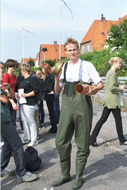
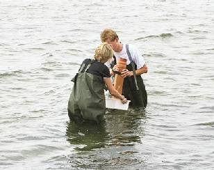
At the test station each group wade out (dressed in waders or bathing suits according to the season) and collect a bottom sample with the bottom sampler tube. On site the sample is passed through a 1-mm sieve and the sifted material is brought back in a glass jar. |
|
|
|
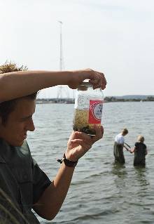
At home the animals are observed and sorted out according to species. The number of animals is calculated for each species. The animals may be fixated in 70% alcohol (professionally formalin is used, as for instance worms disintegrate in alcohol, but formalin is extremely poisonous.) The animals are weighed after the liquid has been dabbed off with a sheet of blotting paper. Finally the weight of the animals are noted as bio mass (wet weight) in g/m2 |
The results of each group are listed as in the diagram below,
Measured Calculated
|
Number of species i one sample of 0,01 m2: |
Number of animals |
Total weight |
Number of animals per m2 |
Weight per m2 |
|
Nereis (Nereis diversicolor:
Tangloppe (Gammarus locusta)
Slikkrebs (Corophium vol.:
Østersømusling (Macoma baltica) |
5
30
1
1 |
0.61 g
3,01 g
0,13 g
0,50 g |
500
3000
100
100 |
61 g
301 g
130 g
50 g |
|
SUM: |
|
|
3700 |
542 g |
Remember when you set out to bring: A bottom sampler, waders, a 1mm sieve, a glass jar for the samples, a plastic container for water (for the animals), and if possible some microscopes with which to observe the animals.
At home: Books for identification, 70% alcohol, a weight, and some blotting paper.
|